

USDA NASS Releases Finer Field Resolution of Cropland Data Layer
One fun announcement from last week’s, USDA Agricultural Outlook Forum was the release of a finer resolution of field boundaries in the continental United States. The United States with the exception of Hawaii is available at a 10-meter resolution. This means that each pixel on the map is accurate to an area 10 meters by 10 meters. Prior to this February 2025 release, the resolution of the images was at 30-meter resolution.
There are two sites from which to access this Google Earth-curated data:
The menu options differ a bit for each one, but the data is the same.
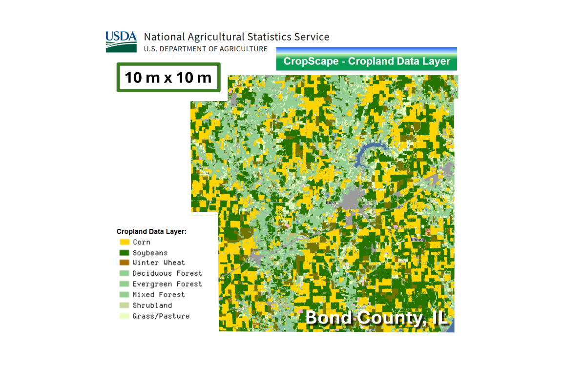
This image provided today is of our tiny Illinois County of Bond and was pulled from the first site above. The yellow fields represent 2024 corn fields, the green fields are a 2024 soybean crop, and some wheat fields (brown). The major Shoal Creek watershed runs from north to south on the western side of the county(lighter green forest and pastures). Interstate 70 angles across the county from the southwest to northeast. The gray blob in the center is the county seat of Greenville.
This data upgrade is significant and likely moves USDA spatial data into a more accurate format than USDA tabular data. Each application will influence that determination. But for 30 years there have been shifts in the best format to receive public USDA data.
When USDA took over the Census of Agriculture from the Census Bureau in the Commerce Department in 1997, it found itself curating two national land use datasets: The NRCS, Natural Resource Inventory and the NASS, Census of Agriculture. In 2003, in preparation for the release of both 2002 datasets, USDA invited Biomass Rules to better understand how the two land use datasets fit together and sometimes why they didn’t.
The land area was the same in both datasets. But each data tool had different objectives and different methods for collecting their data. Both were excellent and trustworthy tools. But they were best used to their strengths. The NRI is excellent at benchmarking land use and land use change. The Census of Agriculture is a better reflection of agricultural activities occurring within each county in the US.
The spatial data first became available in 1997. In 2011 and 2012, while modeling bioenergy related cropping pattern shifts at the UC Davis, California Biomass Collaborative, we were part of a large USDA NIFA funding to look at cellulosic ethanol potential. The target area was 5 states in the Pacific NW. The brilliant young cartographer on the project was very excited to try out the USDA Cropland Data Layer. I was not convinced the accuracy rivaled the county-level, Census of Agriculture production data. He suggested a side-by-side comparison. The results indicated the cropland data layer matched the Census of Agriculture data about half the time. We used the county-level Census of Agriculture data down to the county. Then within the county we use the CDL to bring a higher resolution.
About 10 years ago, studies began emerging about grass land losses in the upper great plains. The analysts involved were using the Cropland Data Layer to make those assessments. While an Extension Specialist at University of Missouri about 10 years ago, my path crossed with the Missouri Director of the NRCS, NRI data. When asked which was more reliable the CDL or the NRI, his response was the NRI was still a more reliable source of land use data.
The adoption of drones and digital field maps, the evolution of crop insurance and timely crop progress reporting has added new pressures to have better spatial data on farm activities.
It was only a matter of time before the spatial imagery of farm activities would reach a new level of accuracy. The release of the 10-meter resolution data last week is likely that passing of the baton. The Census of Agriculture will be invaluable for many years to come, but as far as the crop area activities for one year to the next, the real-time digital land use data of the NASS CDL will be difficult to beat.
Great job, USDA!
Comments
USDA NASS Releases Finer Field Resolution of Cropland Data Layer — No Comments
HTML tags allowed in your comment: <a href="" title=""> <abbr title=""> <acronym title=""> <b> <blockquote cite=""> <cite> <code> <del datetime=""> <em> <i> <q cite=""> <s> <strike> <strong>